Proposed changes to MATA network illustrate system’s potential to change lives
 What should the future of Memphis transit look like? In many cities, people ride the bus to get to school, work, shopping, and other daily activities. Memphis is redesigning its bus system to help people get to more places faster.
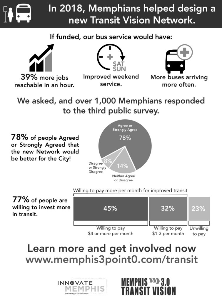
Lead by Innovate Memphis, in partnership with the City of Memphis, the Memphis 3.0 Transit Vision shows what the future of public transportation could be. Through three phases of public engagement, over 2,000 Memphians helped design this future network by responding to public surveys. In phase three, 78% of people agreed or strongly agreed that the new recommended network would be better for the city!
There will be new and redesigned bus routes that changes how people connect across the city. The new network will have more frequent service, which means less waiting and going further, faster, and more weekend and evening service.
With the recommended network, 17,000 more jobs will be reachable within an hour by transit, which is a 39% increase from today. For minority residents, that number will increase to 45% and for low income residents, there will be a 49% increase. A significant improvement with the recommended network is having increased bus frequencies which buses will come every 15 to 30 minutes, meaning 79,000 more people and 103,000 more jobs will be near a 15-minute service route.
To achieve this network, a required new investment of $30 million per year in transit is needed, which includes capital and operating dollars. Survey data shows that 77% of survey takers are willing to invest more in transit.
Learn more about the Memphis 3.0 Transit Vision by reading the reports at www.memphis3point0.com/transit — Courtney McNeal, Innovate Memphis
Cooper-Young’s history with public transportation is long and varied
By Patrick Jones
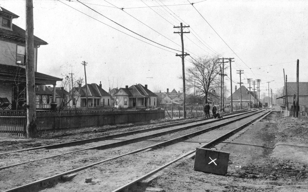
Cooper-Young’s beginnings were inextricably linked to an expansion of public transportation and other infrastructure projects at the turn of the twentieth century. The Greater Memphis movement of the 1890s led to the first major expansion of the boundaries of the city and consolidated several independent small municipalities into the city proper. The city limits reached Cooper Street by 1900 and Trezevant (East Parkway) by 1910. North of Cooper-Young, the cities of Idlewild and Lenox were absorbed into Memphis. Sewers were constructed, schools were built, and municipal services were expanded to the newly annexed areas. Around the same time, several transportation companies serving the city were consolidated into the Memphis Street Railway Company. These earlier companies operated rail transportation on streets within the city along with several routes that ran on dedicated rights-of-way to outlying communities surrounding the city. These routes used everything from mule-drawn rail carriages, steam powered dummy carriages, and newer electric powered streetcars. Following consolidation of this network, an approximately $80 million (in 2018 dollars) street rail modernization and expansion program was undertaken, of which Cooper-Young was a direct beneficiary.
A small community known as Fleece Station had its beginnings in the late 19th century near the Montgomery Park (The Fairgrounds) horse track and the nearby Southern Railroad. This area is generally the southeast quadrant of what is now Cooper-Young. To improve access to the park and the communities in between, the East End Company was established in the 1880s to build a railroad from Memphis, through East End Park, and then to Montgomery Park. It was built on Madison Avenue from Memphis to the east to East End Park (Overton Square), turning south onto Cooper Street, then east onto Young Avenue, passing by Fleece Station and terminating at Montgomery Park. At the time, the communities along this route were largely small groupings of homes and a few storefronts, separated by farms. This railroad became known as “the dummy line” as the engines powering the trains were small steam locomotives known as “dummy locomotives” that were built to resemble the passenger carriages they pulled.
The “dummy line” was quickly one of the more popular suburban railways, shuttling passengers from the crowded city to the amusement park at East End Park and further to horse races at Montgomery Park. Investors bought land along the route and began subdividing lots and building houses. Cities like Idlewild and Lenox were incorporated as parts of these developments. With the consolidation of transportation companies in the 1890s came the numbering of routes, the standardization of fares, and modernization, creating an all-electric-powered network of routes and vehicles. The “dummy line” became route 2. Unlike the reversible trolleys that operate in downtown Memphis today, where the operator merely switches position to drive the vehicle in the other direction at the end of the line, the streetcars operated in Memphis at this time had a defined front and rear. This allowed an unmotorized carriage to be attached to the powered cars during peak hour usage. And thus, at the end of every streetcar route there was a turn loop for vehicles to reverse direction. For route 2, a turn loop existed at East End allowing some vehicles to return downtown from Overton Square. In Cooper-Young, route 2 looped south on a single track onto Bruce Street from Young, then turned east in the middle of the block to a still-existing curb cut at Parkway, then north on Parkway to Young, and west back to the Bruce Street intersection. With the Greater Memphis expansion of the city and city services, another streetcar route was brought to Cooper-Young as part of a substantial infrastructure project. Even though the last rail streetcars ran in 1947 and tracks were subsequently removed, evidence of these improvements are still apparent in Cooper-Young and elsewhere in Memphis.
As part of the expansions of street rail in the first decade of the twentieth century, route 1, which at the time terminated near Lamar and Central, was extended into Cooper-Young from the west, and continued east to Normal Station, where a newly opened teacher’s college had recently opened that we now know as the University of Memphis. Route 1 proceeded out of downtown from the intersection of Third Street, Union Avenue, and Hernando Street, south on Hernando Street, then eastward on Vance Avenue to East Street, turning south to Lamar, and thence on Lamar to Central. Route 1 was then extended east in a single track in the middle of Central, becoming double tracked when turning south onto Barksdale Street, and then turning east in a single track on Young Avenue. Once joining with the double track of route 2 at the Cooper-Young intersection, Route 1 followed Young to Parkway, Parkway to Southern, and then proceeded along Southern east to Highland. East of Highland, route 1 proceeded on its own right-of-way next to the Southern Railroad to a turn loop at the south end of what is now the Alumni Mall in front of the Administration Building at the University of Memphis, and at the time adjacent to the Southern Railroad’s Normal Station passenger depot.
Remnants of route 1’s expansion are evident today. A grass median exists on Central Avenue between Lamar and Barksdale, where route 1’s single track once was. On either side of this segment of Central there are double-wide sidewalks to accommodate pedestrians accessing the streetcars. Proceeding south on Barksdale route 1 became a double track, and in a gentle slope passed under the railroads south of Central. This underpass, called the “Barksdale Street Subway” at the time it was built, was a major project and part of several “subways” constructed for Memphis Street Railway routes during this expansion period. Additionally Barksdale Street, south of Central Avenue was built as a much wider street than Barksdale north of Central, due to the accommodation of street rail infrastructure. The routing of a streetcar line on Barksdale allowed a small commercial district to form at Barksdale and Nelson, where a couple of commercial structures remain today. From Barksdale, route 1 returned to a single track to turn east onto Young. Young Avenue, like the portion of Barksdale south of Central, was built as a wider street east of Barksdale than it is to the west towards McLean Boulevard, again, to accommodate the multiple modes of transportation it carried. Finally, near the end of route 1’s alignment, the road bed that carried the rails east of Highland remains as a narrow road connecting Southern Avenue to Walker Avenue near the University of Memphis.
Perhaps the most noticeable remnants of route 2’s effect on infrastructure is the built environments of the commercial districts it connected. Buildings on the southwest corner of Madison and Cooper, and the northeast corner of Cooper and Young are set back in an arc further from the intersection than the other buildings. This is to accommodate the 90 degree turn radius of a double-track streetcar line, and as one of the more utilized routes the Memphis streetcar system, Route 2 was entirely double tracked and the turning radii at these key intersections had to accommodate not only single vehicle streetcars but streetcars that pulled an extra coach car during peak hours. Similarly to other streets, note that the segments of Cooper north of Madison and south of Young are significantly more narrow, as these segments did not accommodate streetcar infrastructure. Indeed, in many of Memphis’ central neighborhoods, the most tell-tale signs of where streetcars once crossed the city are the old storefronts that line where routes turned, junctioned, or ended, as well as the ways in which different streets become wide where they once accommodated tracks, or become narrow where tracks once diverged in another direction.
The extent to which residents of Memphis relied on their streetcars cannot be understated. That Cooper-Young had two routes connecting it to downtown directly and the industrial areas nearby was a boon to the prosperity of the neighborhood. Even though the last rail streetcar ran on route 2 in 1947, the line continued as an electric trolleybus for years afterwards, and remained a popular option. A Memphis Street Railway Company brochure from 1951, four years after the last rail streetcar ran and well into the rise of the automobile’s post World War II popularity, stated that 54 percent of trips by residents into downtown at that time occurred by bus or trolleybus. One can safely assume the percentages in preceding decades when cars were less prevalent were much higher.
Following the restructuring of the Memphis Street Railway Company to Memphis Transit Company in 1958 and its public acquisition by the Memphis Area Transit Authority (MATA) in 1961, route 2 continued to serve Cooper-Young, first by electric trolleybus until 1960, and since then by bus. The route now extends further south from Young and Parkway to the Airways Transit Center near Memphis International Airport and remains one of the principal routes in MATA’s network. Unlike route 2, at some point route 1 was discontinued. Today, MATA’s route 35 traverses a portion of the old route 1 through Cooper-Young, from Young to East Parkway, thence to Southern, and then east to Highland. Several other MATA routes now serve Cooper-Young on Central and East Parkway.
A Cooper-Young board member’s experiment becomes a new habit
By Robert Hatfield
In February I decided I was going to take the bus for a week. I never stopped riding. What started as a challenge to myself quickly morphed into a pleasant routine. I am currently a student at the University of Tennessee Health Science Center in the Memphis Medical District and during the semester I ride the number 2 or the number 5 to campus each day. This summer I have had part of my program out at Germantown Methodist Hospital, and I have been taking the 50 bus each day.
If you aren’t looking for the big green Memphis Area Transit Authority busses it can be easy not see them as they tend to blend into the background of the cityscape. Once you learn to see them you will quickly realize how many bus routes we have access to in Cooper-Young. The 2, 5, 32, 35, 36, 56, and 57 bus routes either touch or pass through our neighborhood, providing many options for getting around Memphis, especially Midtown, Downtown, and the University District.
MATA busses are also equipped with bike racks on the front that can make many more bus routes quickly accessible from CY. My summer commute to Germantown began each morning with a quick bike ride down Cooper to my bus stop on Poplar across from Overton Park. I would leave the house each morning at 5:45 a.m. and arrive at my stop around 10 minutes later. The 50 bus was scheduled to be there at 5:57 a.m. and was there within 5 minutes of its scheduled time. I would put my bike in the bike rack, swipe my 31-day pass and take a seat. My bus would arrive at my stop across the street from the hospital in Germantown each day at 6:34 a.m. where I would unload my bike to ride around the corner and into the parking lot. I would be drinking coffee in the break room at 6:45 a.m. each morning ready to start my day on time. On the bus I was able check the news, read and send emails, and relax while the bus cruised on down Poplar.
As the semester starts back up, I will enjoy getting back on my regular routes of the 2 and the 5. Both of these stops are only a few minutes’ walk and the bus ride itself is 15 or 20 minutes. With Explore Bike Share and Bird Scooter I feel even more connected. If I want to make a quick trip downtown from campus I can hop on a bike. Bird and Explore also make more bus routes easy to access and can make long wait times for a bus a thing of the past.
If you are interested in trying the bus or have questions about your route, shoot us an email at info@cooperyoung.org. It costs $1.75 for one-way (cheaper for children and seniors) and $3.50 for an all-day pass. Additionally, MATA offers a variety of passes for purchase at their transit hubs that offer a significant discount if you ride regularly. Google Maps has all the routes and times, and a tool where you can use your desired arrival or departure time to see what route would work best. I enjoy the TransLoc Rider app. This app lets you see bus locations in real-time and shows accurate estimates of when the bus will be at a particular stop. MATA has also launched Omnilert, a messaging service which will allow customers to receive emergency/service/information alerts about activity occurring on certain bus routes. I signed up for this and I am currently subscribed to alerts about the 2, 5, and 50. I’ll probably take the 50 off of my Omnilert groups as I’m ending my Germantown rotation, but with Bird Scooters making quick work of crossing the neighborhood I think I might add the 56 that runs down McLean Blvd to my list of possible Medical District routes for the fall.
Hope to see you on the bus soon.